
New Geospatial Research Lab Expands Learn by Doing Opportunities for Students
The Geospatial Systems Research Laboratory (GSR Lab), led by Animal Science Professor Marc Horney, grew out of Cal Poly’s Rangeland Ecology and Management program and supports research and teaching using advanced aircraft, sensors and mapping technologies. The lab provides students, faculty and staff opportunities to develop practical technical skills increasingly used in agriculture, environmental science and land management.
“Geospatial information products are now widely used across all areas of agricultural land and environmental management,” Horney said. “Students who understand how these technologies are used and how the data is developed will be much better prepared to contribute in these fields.
“The Animal Science Department’s connection to this technology comes from the management of grasslands from which grazing livestock produce important agricultural commodities. The Rangeland Ecology and Management program extends its use into the management of habitats for wildlife – which are often co-managed with livestock,” Horney said.
More than 70 students and faculty are currently involved in GSR Lab activities. While most participants are from the College of Agriculture, Food and Environmental Sciences, the lab also includes students from more than 20 majors across all Cal Poly’s six colleges, reflecting the lab’s interdisciplinary focus.
Advanced Technology for Environmental Analysis
The lab uses a combination of mapping software, ground survey equipment and aerial sensor systems to collect and analyze environmental data.
Among the core tools is geographic information systems (GIS), a form of computer-aided mapping used to analyze spatial data. Ground survey technologies include advanced Global Navigation Satellite Systems (GNSS) capable of locating points on the ground within about one centimeter of accuracy and total stations, which use optical systems and laser rangefinders to measure landscape features precisely.
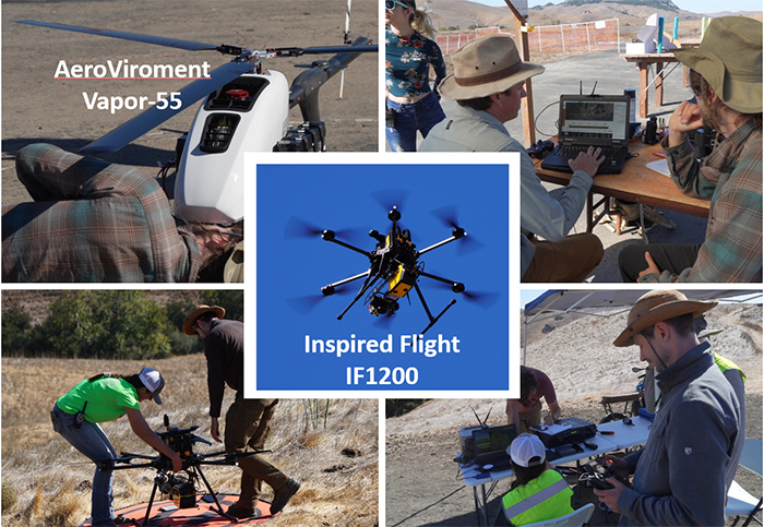
The lab also operates two Federal Aviation Administration (FAA) remotely piloted aircraft — an AeroVironment Vapor-55 electric helicopter and an IF1200A hexacopter. Each aircraft carries multiple sensors that collect detailed environmental information from the air.
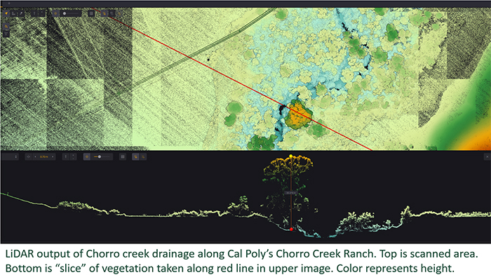
These include an aerial laser scanner, a Sony a6000 digital camera and a MicaSense Altum multispectral imager, which records light and thermal energy across several wavelengths.
Together, the sensors allow researchers to create detailed 3D models of vegetation and terrain and reconstruct landscapes as high-resolution digital twins. Because the lab owns and operates the equipment, the same locations can be surveyed repeatedly to monitor environmental changes over time.
Hands-On Learning in Every Stage of Research
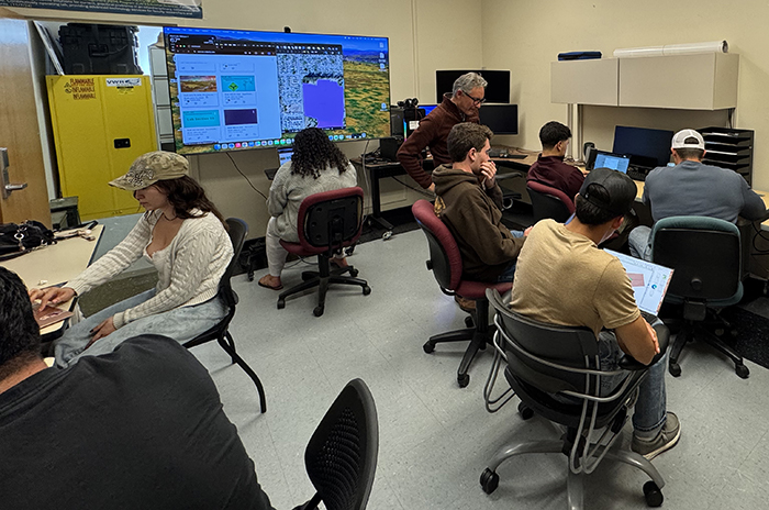
Students working in the GSR Lab participate in every stage of research projects, gaining practical experience in planning, field operations and data analysis.
Teams work with faculty to identify project objectives, develop flight missions that meet FAA and Cal Poly risk management guidelines, and conduct ground surveys to establish control points before aerial flights. Students help prepare aircraft and sensors, carry out flight missions and collect plant and soil data used to verify aerial measurements.
After flights, students process the collected data on lab workstations to generate 3D point clouds, orthographic imagery and GIS information products. These products can include vegetation structure models, landscape maps and vegetation health indicators such as the Normalized Difference Vegetation Index (NDVI).
Horney said the process requires strong communication and attention to detail, skills that develop as students repeatedly work through structured mission checklists.
Supporting Research Across Campus
The lab supports research, coursework and student projects across several academic programs, including rangeland ecology and management, bioresource and agricultural engineering, botany, electrical engineering, environmental management, forestry and fire, landscape architecture and wildlife management.
Imagery and datasets generated by the lab are already being incorporated into courses such as ASCI 239: Principles of Rangeland Management, ASCI 370: Rangeland Improvements, ASCI 460: Rangeland Assessment and Planning and ASCI 490: Advanced Animal Production and Management Enterprise, as well as remote sensing classes taught in engineering programs.
Initial funding for the lab came from the Cal Poly Wildland-Urban Interface Fire Institute (WUIFI), which is using the technology to study wildfire risk detection and evaluate the effectiveness of vegetation fuel-reduction treatments.
Students working in the lab can also pursue FAA’s Part 107 commercial drone pilot certification, gain training with ground surveying equipment and develop advanced GIS and remote sensing skills.
New Facility Supports Collaboration
The lab recently moved into a dedicated space in the Agriculture Building (No. 10), Room 121, consolidating equipment and workstations that were previously spread across several locations and an aircraft hangar at the San Luis Obispo County Regional Airport.
“Having everything together in one secure facility on campus where people can meet and work anytime has been a game changer,” Horney said.
Looking ahead, the lab aims to expand flight operations, collect long-term environmental monitoring data across Cal Poly lands, and develop new partnerships with campus programs, industry and community organizations.
Although the work often focuses on landscapes and ecosystems, Horney said the technology also has major implications for animal science.
“These tools allow us to better understand how animals use landscapes,” he said. “That includes livestock grazing patterns, wildlife habitat use and land management strategies that can support both agricultural production and environmental stewardship.”
Students interested in joining the lab can volunteer regardless of experience. As funding grows, some volunteers may transition into paid research assistant roles.
To make an online gift in support of the Animal Science Department, please use the GIVING link. If you would like to designate your gift for a specific major, scholarship, club or team, please contact Tim Northrop at tnorthro@calpoly.edu
Read more stories in the Spring 2026 Newsletter